
Somerville Block Lookup Sources
A block lookup begins with a parcel row for each visible address, not a guessed household list. The City of Somerville GIS identifies the parcel geometry, building footprint, street centerline, map/block/lot data, and civic layers. VGSI adds the tax-record view. The Middlesex South Registry supplies recorded ownership documents. These sources build from physical location toward record evidence, which is more dependable than assuming a nearby name belongs to the address.
| Block source | Information about the block | Somerville access |
|---|---|---|
| GIS parcels and buildings | Adjacent polygons, frontage, building footprints, MBL, map, block, and lot | Free PropertyLookup and PublicGISViewer services; layer dates vary |
| VGSI street listing | Tax owner, parcel, value, classification, exemption, and mailing versus situs address | Free search and browse route; Assessing counter |
| Middlesex South Registry | Recorded title parties, deeds, plans, easements, liens, and legal descriptions | Free MassLandRecords search and images; Registry counter |
| Permit records | Construction, alteration, demolition, and occupancy history at an address | CitizenServe for current research; historical Inspectional Services route |
| Ward and precinct maps | Election geography and changed precinct boundaries | City and state map resources |
| Public voter list procedure | Publicly releasable registration fields, subject to exclusions | Request from Somerville’s local election office; no public statewide file |
| Directories and poll-tax books | Historical address, ward, precinct, boarder, and community context | Somerville Public Library Local History Room and microfilm |
| Civic meeting records | Neighborhood councils, area plans, meeting notices, and public community contacts | City community meeting and council pages |
Recorded owner, tax owner, historic directory listing, and current resident are different kinds of claims. An owner may hold a parcel through a trust, estate, or organization. A directory listing is historical evidence. A GIS edge shows proximity, not legal title. Keeping each row tied to its source avoids converting a map into a private household roster.
Middlesex County government was abolished in 1997, which explains the split custody behind a Somerville block search. City Assessing and GIS hold the municipal parcel side, while the separate Middlesex South Registry in Cambridge keeps the land-record side. A block record therefore needs both the city parcel identifier and the Registry instrument when title matters.
Somerville Parcel Record Fields
The first map popup supplies the labels needed to repeat the block search later. The official PropertyLookup service identifies the ParcelsSupreme layer with OBJECTID, MBL, MAP, BLOCK, LOT, AddNum, Street, AddNum2, Street2, and additional address fields. An MBL is the assessor map, block, and lot identifier. It is the bridge between a street label, a tax card, and a recorded deed.
Take care with multi-address parcels. The GIS can have a second number and street field, or a parcel may relate to several buildings. Treat each displayed address as a separate research lead, then inspect the assessor detail before counting the addresses as separate parcels. The parcel shape is GIS geometry, not a certified survey. Legal questions require the controlling deed, plan, survey, or Registry record.
- MBL
- A map, block, and lot identifier used to connect the parcel map with assessor and record research.
- Situs address
- The physical location of the parcel. It can differ from the tax owner’s mailing address.
- Frontage
- The parcel’s street-facing edge, useful when deciding which properties form the same immediate segment.
- Parcel polygon
- The mapped shape used for GIS display. It is a location aid, not a legal boundary determination.
Somerville Block Records and Owners
The adjacent-parcel method starts with a selected address and moves only to lots that share a boundary or face the same street segment. It is deliberately smaller than a full street search. Use the map to establish the spatial relationship first, then use VGSI and the Registry to distinguish tax information from recorded title. For a whole named street, the longer process belongs in the Somerville street directory.
- Locate the subject address in PropertyLookup or PublicGISViewer. Record the selected polygon’s address, MBL, building footprint, and frontage.
- Click or identify parcels that touch the boundary or face the same street segment. Compare their map, block, lot, AddNum, and Street fields.
- Open each parcel’s Somerville VGSI detail. Keep the tax owner, mailing address, situs address, tax year, classification, and exemption in separate fields.
- Use Middlesex South Registry property or deed search for the legal ownership trail. Record the grantee, grantor, document, date, book/page, and legal description.
- Save the research date, service and layer name, MBL, address, and map image. The city’s layers do not all have the same update date, so that snapshot matters.
A compact record trail has four confidence levels: spatial match from the GIS, tax match from VGSI, title match from the Registry instrument, and historical occupancy match from a dated directory, poll-tax book, census, newspaper, or voter record. One level should not be promoted into another without a supporting source.
Somerville GIS Block Records
Somerville’s GIS is more than a parcel outline. The city’s PropertyLookup layers include parcels, buildings, street centerlines, city limits, and nearby-city context. The broader PublicGISViewer service adds neighborhoods, wards, precincts, zoning, roads, aerials, polling places, open space, and other location layers. The enCodePlus layers add local historic districts, flood zones, wetlands, transit, neighborhood plan boundaries, and zoning-by-parcel information. These layers help explain the setting of a block without identifying a private household.
The official PropertyLookup service provides the parcel-side layer inventory used for adjacent-address review.
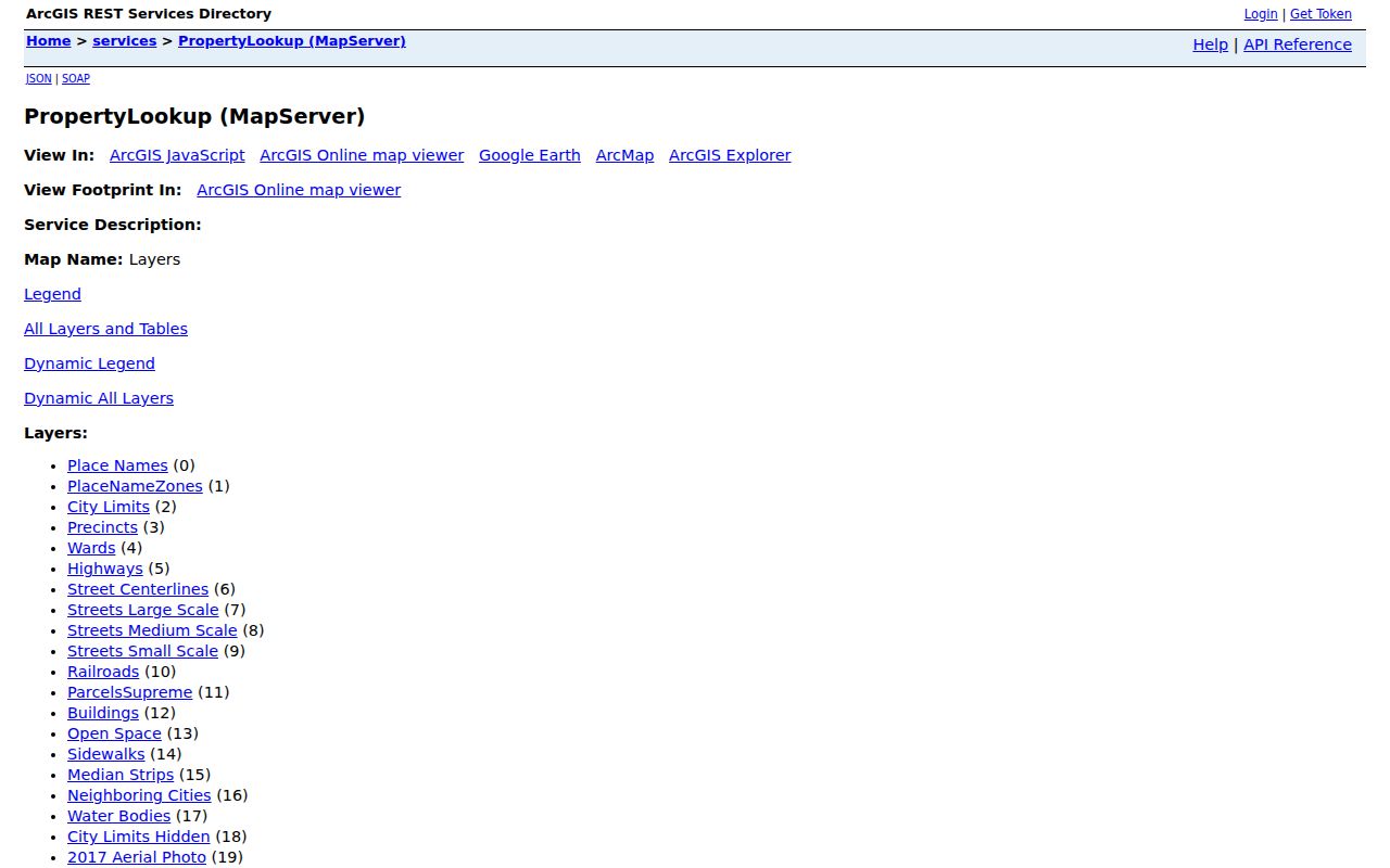
Read the MBL and address fields from the selected parcel before moving to any nearby polygon. That simple order avoids treating visual proximity as a shared title or household connection.
The PublicGISViewer service supplies the ward, precinct, neighborhood, zoning, street, building, and aerial context.
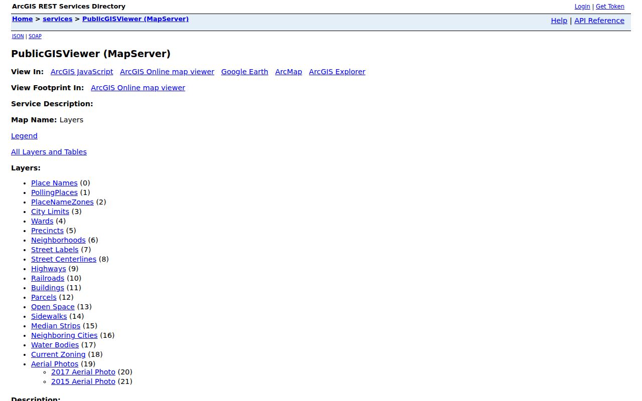
Layer boundaries are independent. A street can cross neighborhoods, wards, precincts, ZIP areas, or city-limit edges. Use the active layer name and its date in any saved note, and never present a polygon edge as a survey line.
Somerville Voter Records and Limits
Massachusetts distinguishes the individual voter-status tool from a local public-record request. The state’s voter registration status form is expressly for the individual voter and requires first name, last name, birth month, day, year, ZIP code, and an acknowledgement. It is not a public address-by-street lookup. Do not automate or repurpose it for a block study.
For a lawful Somerville public list request, contact the Elections or Election Commission records route through the City Clerk and specify the city, election date or range, desired format, and whether the request concerns the public list or a particular registration record. The Secretary says public local voter information can include fields such as name, residence address, party, date of birth, status, voter ID, registration history, and elections voted. It does not reveal ballot choices. The statewide voter file is not a public record.
Confidential voters, minors, phone and email data, veteran status, permanent absentee status, and protected addresses are withheld. Somerville reprecincted after the 2020 Census, so a historical voter or poll-tax lead should be read against the ward and precinct map for its date. The library’s 1887–1938 poll-tax directories are historical address and ward sources, with the important pre-1920 men-only limitation.
Note: A voter entry is dated registration information, not a declaration that a person currently lives at the address or belongs to every nearby household.
Somerville Civic Meetings and Councils
Somerville’s community layer is a public civic contact layer, not a member directory. City material describes neighborhood councils as voluntary, self-organizing, democratic, and representative bodies under the Community Benefits Committee framework. The city’s community meeting page routes people through East Somerville, Assembly Square, South Union Square, Perry/Lincoln Park, Beacon Street, Prospect Hill, Spring Hill, Central Hill, Winter Hill, Ten Hills, Magoun Square, Ball Square, Cedar/Lowell, and West Somerville areas.
The city did not publish a comprehensive association membership roster in the reviewed material. Public meeting notices, committee assignments, area plans, open contact paths, and council records are the appropriate tools for learning what is happening around a block.
Union Square Neighborhood Council
Named by city materials as a neighborhood-council and community-benefits participant. The city page does not publish a member roster.
Gilman Square Civic Advisory Committee
Listed in City Council committee assignments. Meeting records are the official accessible layer.
Winter Hill and Brown School Groups
Appearing in city committee listings, these are civic advisory channels rather than private household lists.
Ward and Community Meetings
City meeting pages provide public contacts and area routing. Submitted-comment addresses are redacted from the public agenda view.
The Somerville community meeting page is the source for the official neighborhood and ward routing shown here.
Use a neighborhood label to find relevant public meetings, plans, and civic documents. It should not be treated as a list of who lives within that labeled area.
Somerville Block History at the Library
For a past block, the Somerville Public Library Local History Collection provides the most useful bridge from parcel to people-record context. City directories run 1851–1933 by name and 1939–present by ward, precinct, and address. Poll-tax books run 1887–1938 by ward, precinct, and street address. The library also identifies newspaper microfilm, a subject and obituary index, historic maps, Sanborn material, phone directories, census access, yearbooks, and a vertical file.
Earlier books are not a modern block list. A 1905 directory can show a person at an address for that publication year, while the poll-tax book offers a ward and street clue. Pair either one with a deed, map, census, or newspaper date before reaching a conclusion. The 1889 directory’s four-ward geography is historical, not the modern seven-ward arrangement. That change matters when a street segment is followed over many decades.
Somerville Block Privacy Boundaries
Public parcel, assessor, and Registry records can show a parcel and a recorded or tax ownership trail. They do not show every household member, visitor, utility account, delivery information, or protected voter connected with that address. Massachusetts Address Confidentiality Program participants, confidential voters, sealed or impounded court matters, and protected vital-record information have separate limits. A no-result means only that the selected record did not produce a public entry.
Commercial neighbor tools often combine mixed records. Their entries can be stale, incomplete, or conflated across people with similar names. They are not a substitute for the dated source record. Use the official layer that matches the question, and retain the parcel ID, source name, and research date.
| Official record layer | Commercial neighbor tools |
|---|---|
| Has a named custodian, defined record type, and access limits. | May combine data from different sources and times. |
| Can support a limited statement about a parcel, instrument, or dated registration record. | Cannot establish a complete private household or replace the custodian’s record. |
| Allows the reader to inspect the source date and record context. | May not show how a listing was assembled or when each component changed. |
Lawful use. Somerville neighbors research belongs to documented property, local-history, and civic-context questions. Do not use address records to watch, harass, intimidate, or harm any person.